(Click for modern and Book of Mormon names.)
by John P. Pratt
21 Jun 2020, 1 Flower (SR), 1 Resurrection (V), 1 Summer (E,S)
©2020 by John P. Pratt. All rights Reserved.
|
1. Scientific Falsification 2. Mormon's Map 2.1 Mormon's Description 2.2 Mormon's Map from BYU 3. Heartland Model Falsified 3.1 Narrow Neck of Land 3.2 Nearly Surrounded by Water 3.3 East-West Wilderness Strip 3.4 River Sidon Flows North 3.5 Lehi Landed from Sea West 3.6 Separate Civilizations 3.7 Nephites and Lamanites 3.8 Limited Extent 3.9 Named Lands 4. Conclusion Notes |
The Book of Mormon describes a long ocean voyage by a family from Jerusalem leaving from the eastern side of the Arabian peninsula and landing on the western coast of the Western Hemisphere. They wrote that they lived in the "Land Southward" which was separated by a "small neck" of land from the "Land Northward". At first it seemed obvious that this referred to South America separated by the Isthmus of Panama from North America.
|
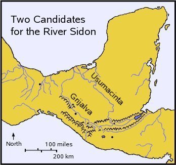
There were two competing suggestions for a major river of the area called the River Sidon, which flows northward in the Land Southward: The Grijalva and the Usumacinta (see Figure 2). I attended a debate at BYU in the 1960s between Bruce Warren, who favored the Grijalva and Garth Norman who championed the Usumacinta. Then John L. Sorenson became chairman of the Anthropology Department of BYU (1979-1980). He adopted the Grijalva model, which suppressed most of the debate. That model became synonymous with the "Mesoamerican Model". When researchers rejected Sorenson's model for archaeological and other reasons, the whole Mesoamerican model was discarded in the minds of many, so other settings were sought for the Book of Mormon narrative.
 |
The more recent "Heartland Model" places virtually all of the history of the descendants of Lehi during Book of Mormon times in the United States. It has gained surprising success, being highly promoted commercially. I attended one of their large conferences where the lead speaker began by stating that attempting to use the map given in the Book of Mormon has only led to confusion, so this new approach is to ignore Mormon's map and just look where the archaeology is good. It turns out they have indeed done a huge amount of excellent archaeology and have made a great case for the existence of Nephites in America after about 100 BC. That is about when the Book of Mormon states that some 5,400 families fled north (Alma 63:4), so in my view, all of the results presented as evidence of Nephites in the Land Northward can be explained by those who migrated north from Mesoamerica.
It has appeared that my 2006 summary of the case for the Usumacinta River being the Sidon of the Nephites did not need updating. Now, however, I see that one researcher has listed as one reason to discard that model is that it has not been updated in 31 years.[3] That comment inspired me to write this article. Should we discard the map given by Mormon because he has not updated it?
This article reviews the method of scientific falsification in preparation to use it to reject all of the Heartland Models. It then reviews the map given by Mormon in Alma 22, quoting both his description as well as the best graphical rendering of it done at BYU.[4] Most researchers agree on the large features of this virtual map because they come right out of the Book of Mormon. It is essentially the same in general as the map in my 2006 article. The purpose of this map is to compare it carefully to any of the Heartland Model maps, which depend on statements of early Church leaders, rather than on the Book of Mormon. It is hoped that readers will see that none of those models can be correct if Mormon's Map is accurate!
On the other hand, in all fairness to the Heartland Model, some of its proponents openly admit that they are making little effort to fit Mormon's Map. Their approach seems to be to study all of the archaeology first, the pick out the names of lands of the Book of Mormon, and place them where it seems best. If so, then it is meaningless to subject their model to the test of matching Mormon's Map, because it is known at the outset that it will not match.
That being the case, the purpose of this article becomes a red flag to announce to readers that the Heartland Model is incompatible with Mormon's Map. But that does not mean to reject all of the wonderful archaeological evidence the Heartland researchers have discovered of Lehi's descendants dwelling in America. All truth is from God and worth treasuring! To me this result only means that all of those archaeological finds date to after the northward migration from Mesoamerica of 57 BC.
 |
The steps of the scientific method are (1) make an observation in nature, (2) suggest an explanation (hypothesis) of what caused it, (3) design an experiment to test your hypothesis, that is, either set up the conditions which your hypothesis predicts will cause the expected result, or wait until they occur naturally, (4) observe the results to verify that your predicted results happened. If the results do occur as predicted, it does not prove the theory true, because the result could have been caused by something else. No scientific theory is ever proven true! But if the predicted result fails to occur, then the hypothesis is proven false! The hypothesis is said to be falsified. It is then time to either discard the hypothesis entirely or modify the hypothesis and begin the procedure again.
What has the scientific method got to do with Book of Mormon geography? Mormon, the compiler of the Book of Mormon, provides a map of the land in which the Book of Mormon occurred. That is the observation of nature. Different researchers have produced various hypotheses or theories about just what area Mormon was describing. Each of these can be tested against Mormon's observations to see if they produce the predicted result. If they do not, then the theory is falsified! That is, the theory is proven false, provided that Mormon's observations were correct and that we understood them.
 |
Let us begin by reading the actual quotation where Mormon describes the landscape. He interrupts his narrative to provide geographic details apparently for two reasons. First, the king of all of the Lamanites makes a proclamation to his entire kingdom, and the history compiler Mormon wants the reader to understand its extent and the lay of the land. Secondly, much of the rest of the Book of Alma will describe wars between the Lamanites in the south with the Nephites in the north, and he wants the reader to understand that when Captain Moroni built seven cities along the narrow strip of wilderness, that it formed a wall which completely hemmed in the Lamanites in their own land to the south, because that strip extended all the way from the Sea East to the Sea West.
When the name "Mormon's Map" is used in this article, it refers only to the following seven verses of the Book of Alma, where Mormon inserts a description of the geographical location of the events he is describing. That name does not include the many other verses of the Book of Mormon which give geographical clues. None of those other references contradict anything that Mormon states, so these few verses seem sufficient to define a standard of minimum requirements which any candidate map would need to fulfill.
Here is Mormon's description of the Book of Mormon setting:
27. And it came to pass that the king sent a proclamation throughout all the land, amongst all his people who were in all his land, who were in all the regions round about, which was bordering even to the sea, on the east and on the west, and which was divided from the land of Zarahemla by a narrow strip of wilderness, which ran from the sea east even to the sea west, and round about on the borders of the seashore, and the borders of the wilderness which was on the north by the land of Zarahemla, through the borders of Manti, by the head of the river Sidon, running from the east towards the west--and thus were the Lamanites and the Nephites divided.
28. Now, the more idle part of the Lamanites lived in the wilderness, and dwelt in tents; and they were spread through the wilderness on the west, in the land of Nephi; yea, and also on the west of the land of Zarahemla, in the borders by the seashore, and on the west in the land of Nephi, in the place of their fathers' first inheritance, and thus bordering along by the seashore.
29. And also there were many Lamanites on the east by the seashore, whither the Nephites had driven them. And thus the Nephites were nearly surrounded by the Lamanites; nevertheless the Nephites had taken possession of all the northern parts of the land bordering on the wilderness, at the head of the river Sidon, from the east to the west, round about on the wilderness side; on the north, even until they came to the land which they called Bountiful.
30. And it bordered upon the land which they called Desolation, it being so far northward that it came into the land which had been peopled and been destroyed, of whose bones we have spoken, which was discovered by the people of Zarahemla, it being the place of their first landing.
31. And they came from there up into the south wilderness. Thus the land on the northward was called Desolation, and the land on the southward was called Bountiful, it being the wilderness which is filled with all manner of wild animals of every kind, a part of which had come from the land northward for food.
32. And now, it was only the distance of a day and a half’s journey for a Nephite, on the line Bountiful and the land Desolation, from the east to the west sea; and thus the land of Nephi and the land of Zarahemla were nearly surrounded by water, there being a small neck of land between the land northward and the land southward.
33. And it came to pass that the Nephites had inhabited the land Bountiful, even from the east unto the west sea, and thus the Nephites in their wisdom, with their guards and their armies, had hemmed in the Lamanites on the south, that thereby they should have no more possession on the north, that they might not overrun the land northward. -- Alma 22:27-33.
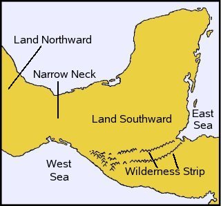
The LDS Church has decided not to take a stand on supporting any one model for understanding the locations of Book of Mormon events. In view of that, one thing that Brigham Young University (BYU) has been able to do in order to help understand the geography is to produce a realistic rendition of Mormon's Map (see Figure 3). It agrees in the overall features with almost everyone's version of Mormon's Map because all are deriving it from the text quoted above.
Mormon's Map has all of the key features which the prophet Mormon felt we needed to understand in order to understand the extent of the Lamanite kingdom and to be able to appreciate the war descriptions which would follow. If the reader can simply look at this map and notice that it is entirely different from any map of North America or of the Heartland Model ever seen, then there may be no reason to continue reading this article. That is, this map alone discredits the Heartland Model. If, however, you'd like to know how this map was derived, in order to know how much to believe it, read on.
 |
The method proposed here to falsify the theory that a model of Book of Mormon having occurred in the United States can be consistent with Mormon's Map. This approach treats Mormon's observations as the "facts" of the geography which need to be matched by any candidate to be the actual geographical map. The steps are to derive nine criteria from the facts from Mormon's description of the Book of Mormon lands which any candidate theory must meet in order to be consistent with his map. These criteria will be discussed and used to build Mormon's Map step by step. That is, it will give the reasons for each of the major features of that map, but not the location of any specific cities. This entire section is based only on the seven verses quoted above describing the land's layout.
The method of falsification is simply to look at the Unites State topography and note that most of the criteria cannot be fulfilled. Failing on any one of these criteria would suffice to falsify the theory.
One of the most striking features of the landscape is that there is "a small neck of land" between the Land Northward and the Land Southward (v. 32). Almost all of the Book of Mormon narrative takes place in the Land Southward. The distance across the narrow neck is given as the distance a Nephite can cross in a day and a half.[7] The direction of the narrow neck is not specified, but only that it separates the Land Northward from the Land Southward.
This narrow neck separates the Sea East from the Sea West in the area between the land Bountiful and the land Desolation, Bountiful being the northernmost of the Land Southward and Desolation being the southernmost of the Land Northward. Both Bountiful and Desolation stretch from sea to sea (v. 31-32).
Comparing this requirement to a map of North American, most Heartland models choose one of the Great Lakes to be the Sea West and another to be the Sea East. There are no shortage of narrow necks between them; various have been chosen for that isthmus. The main problem is that the Heartland models do not confine all of the Lands of Zarahemla and Nephi to be between those two "seas".
 |
These first two requirements are also shown in Figure 4, based on the maps from my 2006 article. This criterion is not fulfilled at all by the Heartland Models! They tend to place Book of Mormon history all the way from the Mississippi River to the Atlantic Ocean and south to about Tennessee. This area is not at all surrounded by water. They attempt to fulfill that requirement with land between the Great Lakes, but Mormon's Map makes it clear that all of Bountiful, Zarahemla, and the Land of Nephi are all in the the Land Southward. Look at any Heartland map to see that all of those lands are not nearly surrounded by water!
Failing to satisfy this one requirement alone is enough to falsify the Heartland Models, but let us continue. Remember that they admitted that some of the researchers were not trying to fit Mormon's Map because that only led to confusion!
Now we come to the very hardest requirement to fulfill. It is a wilderness strip that extends from the Sea East to the Sea West (v. 27). It is apparently so hard to cross that it serves as a boundary to hem the Lamanites in to the south of it, protecting the Nephites to the north.
Is there any such wilderness strip going across Heartland America to separate the Nephites from the Lamanites, when the latter were constantly trying to conquer those to the north? The Heartland Maps known to me which include this feature identify it as an imaginary east-west line near the middle of Missouri or as the Ohio River. Neither qualify in any way whatsoever. The Heartland Models fail to fulfill this criterion!
 |
This tells us two things. First of all, the wilderness strip contains a mountain range because that is where the headwaters of large rivers are located. Secondly, it means that the River Sidon runs overall in a northerly direction, away from the east-west mountains and towards the sea. Both the mountainous wilderness strip and River Sidon are illustrated in the logical map in Figure 5.
It is in the requirement for a wilderness strip and a northerly River Sidon where the Heartland Model exposes the fact that it is actually making no attempt to follow Mormon's Map! The Mississippi River flows south, with its head waters being in Minnesota. Mormon puts the head of the Sidon in the Land of Manti, south of Zarahemla.
Thus, the Heartland Model entirely fails to fulfill this requirement!
 |
Every version of the Heartland Model known to me identifies one of the Great Lakes as the Sea West. All of them put the landing of Lehi at the mouth of the Mississippi River, which they identify as the River Sidon, probably because it would be absurd to have Lehi landing at the Great Lakes. Here we see that no attempt whatsoever is made to agree with Mormon's description.
The Lord told Nephi to take his followers and flee from Laman, so they left and went to what became known as the Land of Nephi. From the text, it sounds like like they went perhaps a hundred miles away, far enough to be safe from the immediate threat. In the Heartland Model they build boats and paddle upriver from the Gulf of Mexico to about where Tennessee is today. Nothing like that means of travel nor distance is hinted at in the text. Moreover, that would mean that the land of first inheritance is south of the Land of Nephi, whereas Mormon said it is west of the land of Nephi (v. 28).
In the history, we are told that another group of Israelites also crossed the ocean about the same time as Lehi and landed near the narrow neck of land. They also built an entire civilization which lived for centuries near the Nephites without the two groups having known about each other. How could that be? Some skeptics have scoffed at the idea.
Mormon's Map makes the story much more plausible. The northern group, called Mulekites in their land of Zarahemla, were separated from the Nephites by the mountain range in the wilderness strip which goes from sea to sea. Later on, it was hard enough to cross to separate the Nephites, who went north to join the Mulekites, from their Lamanite enemies to the south. If it was that difficult to cross, it could also have separated the earlier Mulekites north of the mountains from the Nephites in the south.
Thus, we see that the mountain wilderness was substantial! In the Heartland Model there is no such wilderness strip at all, much less one from Atlantic to Pacific, because no east-west mountain range exists in the eastern United States. In the actual history, it was a very significant wall of separation, which is why the prophet Mormon felt to tell us about it. Figure 6 shows where Nephi's people later spread from the area where Lehi first landed, and also the location of the Mulekites in Zarahemla, north of the mountain range.
 |
The Nephites and Mulekites joined together to be called simply the Nephites. Thus, at the time of Alma, the Nephites were north of the wilderness, and the Lamanites eventually filled the Land of Nephi, which seems to merit yet another map (see Figure 7).
These moves should also be accounted for on any map which proposes to depict the location of the history of the Nephites and Lamanites in the Book of Mormon. In particular, the moving of the Nephites further and further north over time.
Mormon also gives us a huge clue as to the size of the part of Land Southward south of the wilderness strip where the Lamanites lived. At the very beginning of his description of the land, and apparently one reason for providing the map for the reader, he tells us that the king of the Lamanites sent a proclamation throughout all of his kingdom, from the Sea East to the Sea West (v. 27).
That one sentence gives some indication of the size of the entire Lamanite land which stretched from sea to sea. Given that the proclamation would be sent by messengers, just how big might his kingdom have been?
The main point here is that the huge extent of the Heartland Models, being most of the eastern half of the United States, seems far to big for the Lamanite king to have ruled the southern half of it. Moreover, those models do not place the Lamanites in the area between the Sea East and Sea West, which they identify as members of the Great Lakes.
Mormon names several lands in those seven verses describing his map, and gives some information about their relative positions.
 |
Bountiful was just below the narrow neck, and hence part of the Land Southward. Desolation, being past the narrow neck, was the southernmost part of the Land Northward. All of that is shown in Figure 8.
Almost none of this fits the Heartland Model at all, because the big areas of where the Nephites and Lamanites lived are throughout heartland America, whereas their narrow neck is in one of the connections between two of the Great Lakes.
One simple test of the Heartland Model is to look for the land of Manti. It should be located near the headwaters of the Sidon River and also south of the land of Zarahemla on the north side of wilderness strip, according to Mormon (v. 27). The maps known to me of the Heartland model either place Manti at the headwaters of the Mississippi in Minnesota hundreds of miles north of their wilderness strip (Missouri) or they have Manti in Missouri nowhere near the headwaters of their River Sidon (Mississippi River).
Thus, the Heartland Model abandons Mormon's Map almost entirely.
While engraving the Plates of Mormon, from which the Book of Mormon was translated, the prophet Mormon wrote a brief, seven-verse description (Alma 22:27-33) of the lands in which nearly all of the history took place. It gives the names and relative positions of several lands and describes several striking features. Among those are that there is a Land Southward separated from the Land Northward by a small neck of land. The Land Southward is the location of the Book of Mormon history of Lehi's descendants. It is nearly entirely surrounded by water and is divided into two parts by an east-west, sea-to-sea, wilderness strip. That wilderness must be mountainous because the headwaters of the River Sidon are located there. Hence, that river must flow in a northerly direction.
Many researchers have drawn their own version of "Mormon's Map", derived from these few verses. Nearly all of these maps agree because all are based on the same text. Until recently, this map has been considered to represent the minimum requirements which any candidate location on earth to be the setting of the Book of Mormon must satisfy. For this reason, BYU has produced an excellent version of this map to be used in research. It is included for reference in this article.
For decades it was generally accepted that Mormon's Map referred to Mesoamerica (southern Mexico and northern Central America), being one of the few areas which meet all of those conditions. In the last decade or so, however, much popular belief has shifted to accept the "Heartland Model" of the central area of the United States, including the Great Lakes, as the area of the Book of Mormon narrative. The reason for this was that the archaeology there is much better, which witnesses of a Hebrew people having lived there after about 100 BC.
This article suggests that all of those results about early Hebrews in North American result from the 5,400 families which migrated to the Land Northward (North America) about 57 BC, but who are not otherwise discussed in the Book of Mormon, except that they built their houses of adobe because of the lack of lumber (Hel. 3:7). While some supporters of the Heartland Model openly admit that they do not follow Mormon's Map, the fact that their map is labeled with the names of Book of Mormon lands can be confusing to the reader, who would naturally assume that those names must match the map given in the text itself.
This article attempts to prove that the Heartland Model map fails to fulfill all of the most important features of Mormon's Map, especially those listed in the first paragraph of this section. It is concluded that the Heartland Model's claim that most of events of the Book of Mormon occurred in North America is incompatible with Mormon's Map.