New Proposed Location for Solomon's Temple
by John P. Pratt, V. Garth Norman, Lance Harding, and Jason Jones
Reprinted from Meridian Magazine (15 Aug 2008).
©2008 by John P. Pratt. All rights Reserved.
Index,
Home
Newly discovered evidence indicates possible original location of Solomon's temple.
Exactly where was Solomon's temple located? Virtually all investigators agree that it was on the
Temple Mount Platform in Jerusalem, but its precise location has been in question.
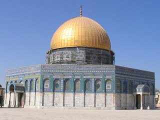 |
The magnificent Dome of the Rock
This article proposes a new location on that platform, where no building presently exists. If
correct, then Solomon's temple could be restored without affecting the magnificent Muslim
mosque, the Dome of the Rock, which is situated where most scholars believe Solomon's temple
had stood.
The evidence presented here was discovered by our team who were sent to Jerusalem last April to research the Temple Mount and surrounding area. Team lead Garth Norman is a professional archaeologist with decades of expertise in archaeoastronomy, Lance Harding is an expert in structural design comparitive study of temples, Jason Jones was our field work engineer and facilitator, having previously lived in Jerusalem, and John Pratt is an astronomer specializing in ancient sacred calendars. The research funding was arranged by Vern Swanson.[1]
1. Historical Background
King David, the father of Solomon, was commanded by the seer Gad to build an altar to the Lord
on the threshing floor of Araunah, the Jebusite. David purchased the site and obeyed (2 Samuel
24:11-25). David himself was not allowed to build the temple, but was told that his son Solomon
would accomplish that great task (1 Kings 5:5). The magnificent temple was seven years in
construction and was finished in King Solomon's eleventh year of reign (1 Kings 6:38).
All tradition and evidence indicate that Solomon's Temple was built at or near David's Altar, atop the hill formerly known to Abraham as Mount Moriah. It is believed that it was the location of Abraham's offering of his son as a sacrifice (Gen. 22:2), and hence the mount is sacred to all believers in Abraham, including Muslims,
Hebrews and Christians. The Temple Platform is located near the southeast corner of the old walled city of Jerusalem.
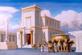 |
Solomon's Temple
Solomon's Temple was built during the tenth century BC [2] and lasted until it was destroyed in
587 BC by King Nebuchadnezzar of Babylon. He took into captivity those of the Kingdom of
Judah who were not slain or scattered, where they remained until the Persians conquered his
kingdom.
 |
Solomon's Temple
Soon after the victory of Cyrus of Persia, the Jews were allowed to return to their country, to rebuild their temple and to worship there. The temple was reconstructed (presumably in the same
location) and is generally referred to as the "Second Temple." It was desecrated by the Greeks in
the third century BC, but then recaptured by the Jews in the second century. Its rededication at that
time is celebrated as Hanukkah each year. It remained essentially intact until the time of King
Herod, who took it upon himself to expand it in the first century BC by more than doubling its size, adding two more pillars in front (for a total of four), and also by increasing the size of the Temple Mount itself.
Titus of Rome destroyed Herod's temple in AD 70 so thoroughly that not one stone was left upon
another, thus fulfilling the Savior's prophecy (Mat. 24:2).[3] That is what has made it so difficult
to locate its precise position on the mount. Rome then erected a temple to Jupiter on the mount,
symbolizing the superiority of their pagan gods to the Jewish. It in turn was removed when
Christianity was adopted as the official religion of the Roman empire in the fourth century AD.
Rather than erect a Christian shrine there, the Romans then allowed the mount to become a garbage dump.
1.1 Dome of the Rock
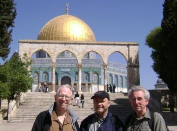 |
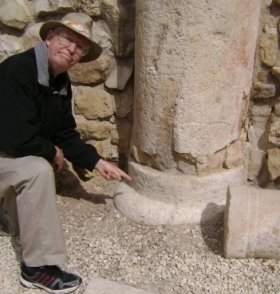
Pratt, Harding and Norman on the Temple Mount near stairs to Temple Platform.
The religion of Islam was born in the seventh century AD. Soon afterward, when the Muslims conquered
Jerusalem, it was their desire to mark the location where their progenitor Abraham had offered his
first born son as a sacrifice. Moreover, it was important in the life of their prophet Mohammed. They restored (and perhaps extended or modified) the original flat area on the Mount called the Temple Platform. They built a
magnificent shrine there over the rock which is the highest point on the mount. Hence that mosque
today is known as the Dome of the Rock. The structure is a marvel and has stood there since AD
691.[4] Humanity owes a great debt of gratitude to the Muslims from having preserved this site until today. Some archaeologists may complain that they would like to have dug it all up, but many are very grateful that the site has been so well preserved. It is generally believed today that the Holy of Holies in Solomon's temple was indeed
located around the Rock. Leen Ritmeyer is the foremost proponent of this interpretation.[5]
Note, however, that the Muslims were concerned about preserving Abraham's sacred Rock altar on Mount Moriah. The Rock may also have been preserved by Solomon to be the altar site for his temple, located southeast of the temple, rather than marking the location of the temple itself.
1.2 Dome of the Tablets
 |
Fig. 1. The Dome of the Tablets (foreground) and Dome of Rock (background)
Although at least a dozen other locations for the temple have been proposed, today the principal
second choice is the Dome of Tablets located near the northwest corner of the Temple Platform (see Fig. 1). This dome marks the location of a hundred square foot patch of what appears to be very flat original bedrock, which is at the level of the entire Temple Platform except for the highest point of the Rock (see Fig. 2). Prof. Asher Kaufman has proposed that it is indeed bedrock and marks the Holy of Holies of Solomon's temple.[6] If so, then a future Jewish Temple (the Third Temple)[7] could be constructed there without interfering with the mosque at the Dome of the Rock.
1.3 Astronomical Orientation
One argument for both of the Dome of the Rock and the Dome of the Tablets has to do with
astronomy. When one looks at the long thin layout of Solomon's temple, the astronomer is struck
by the fact that it would be perfect for letting the light of the rising morning sun (or moon, planet,
or star) shine down its corridors and enter the Holy of Holies on certain sacred occasions.
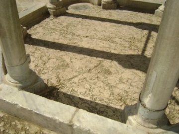 |
Fig. 2. Is the Dome of the Tablets Floor bedrock?
The current Temple Platform is not oriented due east, nor does the east wall of the city run exactly
north and south. The latter is a nearly straight line directed some 6
degrees west of north. The Dome of the Rock has the claim to fame that a line drawn from the
Rock perpendicular to the east wall, points nearly exactly to the summit of the Mount of Olives,
whose peak is some 4 degrees above the Temple Platform's horizon. This alignment suggests that
sacred events might have included the sun rising over the high point of the Mount of Olives and
shining down the axis of the temple into the Holy of Holies. Thus Ritmeyer believes that
Solomon's temple did not face due east, but rather some 6 degrees north of east to the summit of
the Mount of Olives.
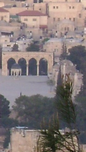 |
Fig. 3. Dome of Tablets at sunrise from the peak of the Mount of Olives.
The astronomical claim of the Dome of the Tablets is that if the Holy of Holies were located there
and if the temple axis did face exactly due east, then that axis also would point directly to the summit
of the Mount of Olives. Thus both proposed locations are tied directly to astronomical orientation
to the high point of the Mount of Olives.
Is there any reason to think that the orientation to the Mount of Olives was important? Indeed there is. While there is not much on record about looking from the temple toward the mount, there was a very important ceremony where a priest looked in the opposite direction, from the mount back to the temple.
The sacred ceremony was the sacrificial offering of the
Red Heifer which was done at a location on the Mount of Olives east of the temple such that when the temple doors were opened the priest would be to be able to see the veil which covered the Holy of Holies.
He was said to stand "on top the Mount of Olives" at that time.[8]
Fig. 3 shows the Dome of the Tablets at sunrise on Sat 5 Apr 2008, as seen from very near the peak of the Mount of Olives (from the roof of the Mount of Olives Restaurant, across the street from the Church of the Ascension, said to be located at the peak). Because we were not allowed on the Temple Mount at sunrise to see the sun rise over the Mount of Olives, we felt the next best thing would be to look the opposite direction, from the peak toward the temple. Thus, this picture shows a view similar to what the priest offering the Red Heifer might have seen.
2. New Proposed Location
Our research objectives included several points concerning the Temple
Mount and the Mount of Olives. In particular the purpose was to examine certain points of Asher
Kaufmann's theory and an extension thereof by Vern Swanson.
During that research our team discovered what appears to be significant evidence strong enough to propose
yet another location on the Temple Platform for Solomon's
temple. Before presenting that evidence, let us briefly summarize some of the key things known
about that temple.
2.1 Solomon's Temple
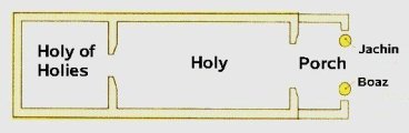 |
Fig. 4. Floor plan of Solomon's Temple
The temple of Solomon had a tall front (30 cubits), and was 20 cubits wide by 60 cubits long (1 Kings 6:2).
The most sacred room, called the Holy of Holies, a cube 20 cubits on a side located at the rear of the
temple. There were two brass pillars in the front which
were even named ("Boaz" on the left and "Jachin" on the right, see Fig. 4). These pillars were 18 cubits tall
(1 Kings 7:15, 21). The temple faced eastwardly and was on a platform which was said to be
500 cubits square. Most scholars are in agreement that the east wall of the square is identical with
the east wall of the city, and it is not pointing due north, but about 6 degrees west of north.
Another point worth noting is that many pictures of Solomon's Temple show it raised up above the platform, as do both of the pictures at the beginning of this article. There is no scriptural basis for that assumption. It is usually made because it has been believed that the temple was situated at the Rock, which would mean that the temple would have to be raised to fit the top of the Rock into the Holy of Holies. Another common idea is that the Holy of Holies itself was raised above the level of the front of the temple for the same reason. Neither assumption finds scriptural support.
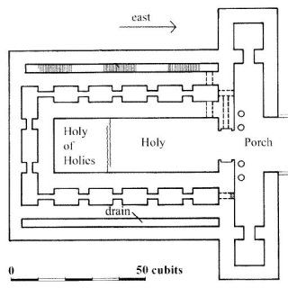 |
Fig. 5. Drainage channel (outside Solomon's temple) was within Herod's expanded temple.
Another important detail is that there were drainage channels on either side to allow rain water to be
saved in cisterns beneath the platform floor. When Herod enlarged the temple he increased its
dimensions, such that the drainage channels were inside of the larger structure (see Fig. 5).
2.2 Formerly Proposed Locations
At least twenty locations have been proposed for Solomon's temple. Each was proposed for a
different reason to solve different problems and explain various pieces of evidence. A
good review of the evidence for each is given in Ritmeyer's book.[9] After having reviewed them all,
the authors of this article have not found where their new proposed location has been suggested
before. Thus we now present evidence for yet another proposed location.
There are at least five reasons for proposing a new location, each of which is clearly visible
today. Let us examine each of these reasons.
2.3 Center Axis
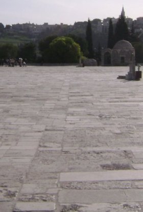 |
Fig. 6. Can you see the single row of stones pointing eastward?
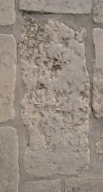 |
Fig. 7. Some stones in axis row appear to be bedrock.
At about 8:30 a.m. on Sun 6 April 2008, we noticed one straight line of stones in the pavement of
the Temple Platform. Most of the stones surrounding this line were of various widths and lengths,
having obviously been cut to whatever shape best fit into the next space. But the stones in the
line were all cut to the same width (see Fig. 6). Moreover, some of these stones appeared to be original
bedrock. They looked nearly identical to the floor of the Dome of the Tablets, which may be
the largest single flat area of original bedrock, being nearly twelve feet in diameter. Several stones
seemed clearly to be bedrock (see Fig. 7). Then
other stones were cut to bring the whole area up to the same level. We propose that this line of stones was the center axis of Solomon's Temple, and that it extended far out in front of that temple.
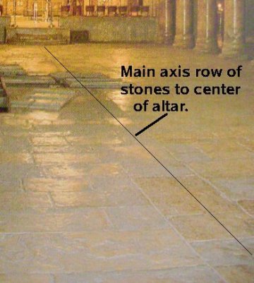 |
Fig. 8. Similar stone row center axis of an AD 335 church.
The location of this central axis (and hence our proposed location for Solomon's Temple) is between the Dome of the Tablets and the Dome of the Rock. It is the extended flat area clearly visible in Fig. 1. In that photo, the temple would be facing to the left (east).
As an example of another church having been centered on a single row of stones, look at the photograph of the Church of the Nativity, built by Constantine in AD 335 (see Fig. 8). It also has a center axis indicated in the floor nearly identical to the row of stones we propose as the axis of the temple.
2.4 Drainage Channels
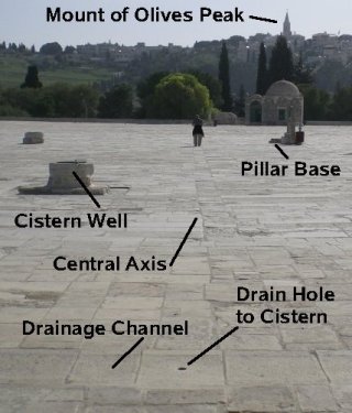 |
Fig. 9. Drainage channel forms west end of the main axis.
There are three drainage channels, one on either
side of and parallel to the center axis and a third at the west end of the central axis. Moreover, the platform floor is nearly level between the three channels, but slopes down to them from the north (as can be seen in Fig. 9). These drains are exactly what would be expected around a building centered on that axis and located east of the western channel. Solomon's Temple had such channels, and Herod's extended temple was built around them without disturbing them.
2.5 Cisterns
There are large cisterns located beneath this entire area, just as there were beneath the Temple of Solomon. There are holes drilled in the drain channels, to collect the water in the cisterns. One drain hole is clearly visible in Fig. 9, in the center of the west drainage channel. Thus, rain water was collected in them and stored for future use. That exactly matches what was needed for use in sacred washings in Solomon's temple. Thus, these drains and cisterns are just what would be expected to be found at the true location of Solomon's Temple. Also visible in Fig. 9 are three wells, two to the left of the center axis and one very near to what is labeled the pillar base. These wells were built later by the Muslims to get water from the cisterns below, which they also can use for ritual washings. Thus, the drains and cisterns are still working today.
2.6 Pillar Base
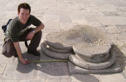 |
Fig. 10. Jason Jones measures possible "Boaz" pillar base.
There is a clover-shaped platform located some 7 paces (10-11 cubits) south of the main axis. It is no doubt a pillar base, and it is at approximately the right distance (about 20 feet) from the center axis to be "Boaz". It has notches carved into it (now filled in), clearly designed to hold a pillar in place. We measured the perimeter of the base to be 556 cm, which is 10.6-12.2 cubits, depending on the cubit used (see Fig. 10). The Bible states that "a line of twelve cubits did compass either of [the pillars] about" (1 Kings 7:15), so it is about the right size. The back of the base is flat, indicating that it was most likely touching the side of a building. The stone is chipped as if it had resisted being moved. It appears to be solidly in place and thus could well be in its original position. If so, the location of Solomon's temple is pinpointed by this stone. That is, the axis determines the orientation and the stone the exact position. Even if the stone is a later addition, it could still mark the original location. This stone is labeled in Fig. 9. It is located to the right (south) of the person standing on the center axis row. The base is partially obscured by a cistern. It is visible in Figure 6 and it also appears between the leftmost two pillars of the Dome of the Tablets in Figure 1.
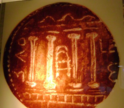 |
Fig 11. A coin with picture of Herod's temple. Note the similarity of the pillar bases to the one still in place.
In the museum next to the Temple Mount, there is a huge a picture of a coin showing the Temple of Herod (see Fig. 11). Note that the pillar bases look very similar to the one we propose might be original to Solomon's temple. Vern Swanson later pointed out that the pillar base
is said to be of the same type used by the Knights Templar when they arrived in the Twelfth Century but
to us it would not be surprising if they used that form because it was discovered on the Temple
Mount. Thus, the authors believe that the pillar base might indeed be the orignal base for the
Temple of Solomon. In any case, it certainly appears that there used to be a building with pillars at that location, aligned with an axis embedded in the original bedrock stone, with drainage channels around it,
and cisterns beneath it. It would have been about the size, shape and orientation of Solomon's temple.
2.7 More Research Necessary
 |
Similar pillar base with stone pillar still intact.
This proposed location is still preliminary because more research is needed to verify it. Unfortunately, at present, most on-site research is strictly prohibited. Additional careful measurements need to be made. Perhaps the pillar base was made for the later Roman temple. Nevertheless, our evidence is much more solid than anything for other proposed locations, much of which is based on groundless speculation. It definitely appears that some ancient building stood there, and it is about the right size, shape and orientation to have been Solomon's temple.
3. Conclusion
Evidence has been presented for the location of Solomon's temple having been situated between the existing Dome of the Rock and Dome of the Tablets. This evidence consists of 1) a central axis row of stones that may contain original bedrock stones directed nearly perpendicular to the east wall of the Temple Mount, 2) a set of drainage channels on three sides of the location, 3) cisterns located below this area fed by holes in the drainage channels, as would be needed for Solomon's temple, 4) a pillar base in about the correct location for the Boaz pillar, and 5) all of the measurements between these features approximately corresponding to the Biblical dimensions. Thus, it is proposed that this site may indeed have been the original site of Solomon's temple. If this location is indeed correct, then the exact location and orientation have been pinpointed in a place where no building currently stands. Thus the temple could be restored there without impacting the Dome of the Rock in any way.
Notes
- Special thanks go to Ellie Sonntag, Vern Swanson, and Cedar Fort Inc., of Springville, Utah, for funding the trip and research.
- The precise date for the dedication of Solomon's temple has been proposed by one of the authors: Sat 19 Sep 972 BC. See Pratt's "The Timing of David and Solomon's Reigns" Meridian
Magazine (12 Nov 2003).
- The date indicated on sacred calendars for the burning of the temple by Nebuchadnezzar is Sun 24 Jul 587 BC, which was 10 Ab (Jer. 52:12) on the Hebrew Calendar and 1 Burning (bpp), the
day for burning of Levi and Judah on the Jubilee calendar. In AD 70 the temple was also
destroyed on 10 Ab and 1 Burning, on Sun 3 Aug AD 70. See Pratt's "Jubilee Calendar Testifies
of Christ," Meridian Magazine (17 Nov 2004), Section 2.5 "Temple Burnings."
- See "Dome of the Rock," in Wikipedia.
- Ritmeyer, Leen, The Quest: Revealing the Temple Mount in Jerusalem (Jerusalem: CARTA Jerusalem, 2006) makes a case for the traditional Dome of the Rock site.
- Kaufman, Asher S. in Proceedings of the International Congress on Biblical Archaeology, A. Biran, ed., (Jerusalem: Biblical Archaeology Today, 1985), p. 484. See also Kaufman, A.S., The Temple Mount: Where is the Holy of Holies? (Jerusalem: Temple of Jerusalem, 2004). Ritmeyer dismisses Kaufman's claim that the floor is bedrock on the grounds that Warren's 1884 estimate put the bedrock perhaps 10 feet lower. He also says it looks like other paving stones, but its size is over a hundred square feet, whereas the nearby stones are rectangles of two to four square feet. Clearly the Dome is there to preserve something important, and it looks to Kaufman and to us that it is to preserve a large patch of original bedrock. Kaufman chooses this location as that of the Holy of Holies of Solomon's Temple. Ritmeyer's other objection to this spot is that Josephus says that the temple was at the "top" of the temple mount. Ritmeyer takes this literally to mean it must have included the Sacred Rock, which projects up from the Mount some 15 feet. To us the less strained interpretation is that the Temple was located on the flat surface of the Temple Platform all of which is atop the Mount. After all, it had been a "threshing floor." See Ritmeyer, p. 163.
- Solomon's Temple is the First, the rebuilding after the exile is called the Second, but neither the Hasmonian restoration nor Herod's expansion is called the Third. That appellation is usually reserved for the future temple. See, for example, Robert Reiland, Jesus and the Third Temple (Silver Springs, NV: Your Own World Books, 2007), which favors Kaufman's theory.
- Middot 2.4 quoted by Ritmeyer, p. 267. See also Karen Boren, Messiah of the Winepress: Christ and the Red Heifer (Beit Parah, 2002).
- Ritmeyer, p. 147 has an illustration of twelve proposed locations for Solomon's temple: De Vogue 1864, Fegusson 1878, Warren 1880, Conder 1884, Schick 1896, Watson 1896, Mommert 1903, Dalman 1909, Mollis 1934, Simons 1952, Vincent 1954, and Ritmeyer 1985. The only one close to the position proposed in this article is the first, that of De Vogue.